
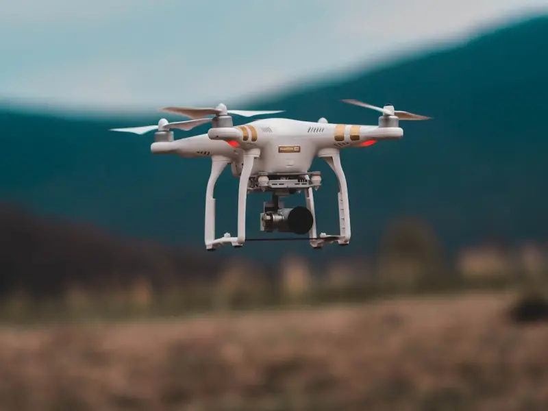
The Sky’s the Limit: Drones Transform Home Inspections
When I first lifted a quadcopter off the garage floor during a routine pre‑sale inspection, the hum of the propellers felt like a secret invitation to explore roofs the way a bird does—without ladders, scaffolding, or the lingering fear of a misstep; in that moment I realized that aerial imaging could become the most honest, unobtrusive witness to a home’s hidden vulnerabilities, capturing high‑resolution panoramas of shingles, flashing, and gutter systems that traditional binoculars simply can’t reveal. Drone technology not only accelerates the data‑gathering phase, shaving hours off a day‑long climb, but also provides a repeatable visual baseline, allowing homeowners and sellers to compare wear patterns season after season with pixel‑perfect precision. As I stitch together orthomosaic maps and overlay thermal overlays, the narrative of a property becomes a story told from above, turning vague concerns about “roof age” into concrete evidence that can be quantified, discussed, and ultimately resolved before negotiations even begin.
Why Traditional Methods Miss the Mark
Even the most diligent inspector can miss subtle signs of degradation when confined to ground‑level perspectives; moisture ingress behind a ridge vent, wind‑uplifted shingles, or a misaligned skylight often hide in shadowed crevices that demand a bird’s‑eye view to uncover, and while ladders give access, they also introduce safety risks and time constraints that limit the thoroughness of the examination; this is why I’ve begun to question the long‑standing reliance on tactile checks alone, especially when a single misplaced step can jeopardize both the inspector’s safety and the integrity of the assessment. By contrast, a drone can hover for minutes, rotate 360°, and capture every angle in high definition, delivering a comprehensive visual record that can be archived for future reference and even shared instantly with clients via cloud platforms. The result is a more transparent process that builds trust, reduces liability, and empowers buyers with the confidence that every nook and cranny has been scrutinized.
Integrating Drones with Existing Inspection Workflows
Adopting aerial tools does not mean discarding the tried‑and‑true tactile methods that have defined our profession for decades; rather, it requires a thoughtful integration where drone footage complements on‑site measurements, moisture meter readings, and the traditional walk‑through, creating a layered inspection that is both visual and analytical; I have started each assignment by planning a flight path that mirrors the foot traffic I would take, then I pause at critical junctions—chimney stacks, vent boots, roof valleys—to capture detailed stills that later serve as reference points for my written report. The synergy becomes especially powerful when paired with smart sensor technology, allowing me to overlay real‑time temperature and humidity data onto aerial images, instantly highlighting areas of heat loss or hidden moisture that would otherwise require invasive probing.
Legal and Safety Considerations: Flying By the Book
Before I ever launch a drone over a client’s property, I double‑check local FAA regulations, obtain the necessary Part 107 certification, and secure written permission from the homeowner, because compliance isn’t just a bureaucratic hurdle—it’s a cornerstone of professional credibility that protects both the inspector and the client from unexpected liability; I also conduct a pre‑flight checklist that covers battery health, GPS signal strength, and obstacle detection settings, ensuring that each flight adheres to the highest safety standards while minimizing the risk of accidental damage to roofing materials or landscaping. When flying near power lines or densely packed neighborhoods, I employ low‑altitude flight modes and set geofencing boundaries, which not only safeguard the equipment but also demonstrate to clients that my approach respects their property and the surrounding community.
Data Management: From Raw Footage to Actionable Insights
High‑resolution video and photo files can quickly balloon into gigabytes of data, so I’ve invested in a streamlined workflow that automatically uploads footage to a secure cloud repository, where AI‑powered software can parse the imagery, flag anomalies, and generate annotated PDFs that integrate seamlessly with the traditional inspection report; this digital backbone ensures that every roof panel, vent, and gutter line is catalogued, timestamped, and accessible for future reference, turning what once was a static set of notes into an interactive visual archive. When I present findings, I pull up side‑by‑side comparisons—last year’s drone map versus this year’s—highlighting progressive wear and offering concrete recommendations for maintenance or repair, which makes the conversation far more data‑driven and less speculative. Clients appreciate the clarity, and insurers often view these detailed visual records as proof of due diligence, potentially lowering premiums.
Cost‑Benefit Analysis: Is the Investment Worth It?
At first glance, the upfront expense of a quality drone, licensing fees, and specialized software may seem steep for a solo inspector, but when I break down the numbers, the return on investment becomes evident: each aerial survey saves an average of 2‑3 hours of manual climbing, reduces the need for additional crew members, and cuts insurance costs by minimizing on‑site accidents, while the enhanced visual documentation commands higher fees from discerning clients who value transparency; moreover, the ability to market “drone‑enhanced inspections” differentiates my services in a crowded marketplace and attracts tech‑savvy homeowners who are willing to pay a premium for cutting‑edge assurance. In my practice, the added revenue from premium packages more than offsets the equipment depreciation within the first six months, making the technology not just a novelty but a sustainable business catalyst.
Client Education: Turning Awe into Understanding
One of the most rewarding aspects of using drones is the educational moment it creates; after the flight, I sit down with the homeowner, walk through the interactive 3D model on a tablet, and explain how a particular shingle pattern indicates wind damage, or how a thermal hotspot pinpoints a failing flash point, turning abstract concepts into visual, understandable evidence that empowers them to make informed decisions about repairs or negotiations; I often reference the home inspection report basics guide to help them translate aerial findings into the language of real‑estate contracts, ensuring they grasp both the immediate implications and long‑term maintenance considerations. This collaborative approach not only builds trust but also reduces post‑inspection disputes, because the homeowner has seen the problem first‑hand, not just read about it in a paragraph of text.
Future Horizons: Beyond Roofs to Entire Property Audits
While the roof remains the most visible beneficiary of drone inspections, the technology’s potential stretches far beyond—imagine coupling aerial surveys with LiDAR to create precise topographical maps for drainage analysis, or using multispectral sensors to assess vegetation health around a foundation, identifying root intrusion risks before they manifest as structural cracks; I am already experimenting with drone‑captured exterior façade scans that feed into BIM (Building Information Modeling) platforms, enabling a holistic view of the building envelope that can inform energy retrofits and even guide future remodeling plans. By positioning the drone as a versatile data acquisition tool rather than a single‑purpose gadget, I foresee a future where every home inspection evolves into a comprehensive, data‑rich audit that addresses structural, environmental, and aesthetic concerns in one unified workflow.
Conclusion: Elevating the Inspection Profession
Embracing drone technology has reshaped my practice from a ground‑level checklist to an elevated, multi‑dimensional analysis that captures the full story of a home’s health, and as more inspectors adopt this aerial perspective, the industry as a whole will benefit from heightened accuracy, improved safety, and richer client communication; the sky is no longer a barrier but a new frontier that invites us to reimagine how we assess, document, and protect the spaces where families live, work, and grow. If you’re curious about integrating drones into your own inspection services, start small—obtain the necessary certification, practice in low‑risk environments, and gradually build a portfolio of aerial case studies that demonstrate value to clients; soon, you’ll find that the lift you gain is not just literal, but also professional, positioning you at the forefront of a more innovative, trustworthy, and visually compelling inspection era.

Lifan Chen is a freelancer based in Toronto specializing in marketing. With expertise in crafting effective marketing strategies and campaigns, Lifan helps businesses grow their brand presence and reach target audiences. As a Toronto-based freelancer, Lifan combines local market insights with creative marketing skills to deliver tailored solutions for clients.
Related Posts

Drone‑Enabled Home Inspections: The Future is Now
A deep dive into how drones, AI, and thermal imaging are reshaping home inspections, offering faster... Read More

The Critical Role of Sustainable Practices in Home Inspections: A Comprehensive Guide
A comprehensive home inspection should consider sustainable practices, energy efficiency, and enviro... Read More
The Importance of Home Weatherproofing: A Comprehensive Guide
Home weatherproofing is crucial for protecting your home from the elements and maintaining its integ... Read More
Top Posts

Transform Your Yard: Sustainable Landscaping Strategies That Wow
Explore practical, sustainable landscaping techniques—from soil health to solar lighting—that create a beautiful, low‑maintenance yard and lower your envi...Read More

Beyond the Brush: Using Color Science to Transform Your Home
Learn to use the science of color to select paint hues that enhance mood, productivity, and wellbeing, while integrating sustainable options and smart testing m...Read More

Creating a Year‑Round Outdoor Living Room: Seasonal Styling and Comfort
Turn your patio into a year‑round haven with durable flooring, weather‑proof furniture, layered textiles, and seasonal accessories for comfort in any climat...Read More
Data-Driven Snow Removal: How to Plan, Prioritize, and Save Time
Discover a data‑focused approach to snow removal that helps you schedule trips, allocate resources, and stay ahead of storms—saving time, money, and stress....Read More
0 Comments
Post Comment
You will need to Login or Register to comment on this post!